Where do you start when you want to make the journey to the highest free-standing mountain and Africa’s highest point? Standing at an astonishing 5895 metre high, it is one of easiest seven highest peaks to summit but still not for the faint hearted.
We used wild frontiers for our trip. Local, reasonably priced but no compromise on quality. With your life on the line the latter is probably more important than the first two. Elite Exped from Nimsdai, (known from the 14 peaks series on Netflix) is on the higher side of the bandwidth probably portion due to fame and high summit percentage. Alpine Ascents is also on the high side, they are known for bringing glamping to highs you did not know were possible.
Now you have committed you obviously want to summit. Three things can make you not realise your dream:
- Altitude sickness.
- Fitness and muscle strength.
- Being under dressed.
- Mountain climbers are at risk of developing altitude sickness. Altitude sickness is caused by ascending too rapidly, which doesn’t allow the body enough time to adjust to reduced oxygen and changes in air pressure. Altitude illness is divided into 3 syndromes:
- acute mountain sickness (AMS) leading to headaches, nausea, and vomiting, loss of appetite, fatigue even when resting, malaise, trouble sleeping, dizziness or lightheadedness, vision changes.
- high-altitude pulmonary edema (HAPE) this is when altitude sickness affects your lungs, causing them to fill with fluid.
- And high-altitude cerebral edema (HACE) is the most severe form. It happens when altitude sickness causes your brain to swell.
Altitude sickness can happen to anybody. The only thing that can mitigate is to acclimatize. Luckily our expedition leader was renowned John Black, South Africa’s first to summit K2. K2 is the 2nd highest but considered the most difficult to climb. He made below program which includes a hike high, sleep low strategy. We hovered around 4000 meters for three days to give everybody the best chance to adapt to lower oxygen levels.
The tour guides normally work on a point system of how severe your altitude sickness is. And oxygen levels in your blood normally give a very good indication if it is time to abort mission. Below 60% is critical.
Luckily besides Altitude sickness you can prepare to increase the odds of your summit.
Below a handy training schedule made by John Black. Try and include walking up and down the staircase (skip steps to recreate uneven steps). Do lunges, reverse lunges, calf raises and leg press in the gym. Lastly don’t go up Table Mountain and down the cable cart. You will need the downhill exercise to strengthen your knees. When hiking up five days and down in two, the speed down and the impact you will endure on your joints needs some preparation.
Training:

Kit kit kit:
You will be dreaming kit. Shall I buy this or that. My recommendation, go in store and try it on. If it feels good, you will be fine. For footwear ask the sales representative to teach you a lacing technique of how to lock your heel in. Fit your hiking boots in the afternoon when your feet are the most swollen. Fit both shoes and one foot is always longer than the other and fit with thick hiking socks to make sure you have the right fit. This way you make sure you will be comfortable and blister free but on summit night have enough space to double up on socks. For me the Altitude range did the trick.
Remember for clothing to buy a size up the further away from the body the layer is (puffer and/or outer shell).
The amount of people I saw walking down with hypothermia was significant. I would say every one person delusional/sick there was a person that was underdressed. So just make sure to buy everything on the list. Summit night I was layered. For the top: One thermal top, one long active shirt, a fleece, a puffer, and a hard shell. Bottom: Thermal long, hiking pants, hard shell pants. I still had a fleece pants in case of emergency cold temperatures.
Because of the long period without electricity, I would recommend a 20000mah power bank or a solar power bank with 4 small solar panels. I insulated my hydration bladder with air conditioning insulation foam (great tip from HI-TEC veteran Chris who climbed Kilimanjaro 20 years before me.
I can recommend additionally throwing in two hand warmers in your backpack to not freeze up your water. Many were running out and came down dehydrated after the summit as a result. Don’t pack too many snacks. The porters will force-feed you to a point I was able to roll down the mountain at day 7. Some were scared they would get hungry and because of the maximum weight you can give to the porters, they were carrying a 12kg day pack! Personally, I enjoyed having my sheepskin slippers in the evening, and a brim hat instead of a cap to be protected against the strong UV index on the mountain. https://hi-tec.co.za/rain-forest-widebrim/
In the rainforest, I enjoyed having a tech long sleeve as it is breathable, and moisture absorbent, and the long sleeves protect against mosquitos (important due to Malaria): https://hi-tec.co.za/mens-tech-longsleeve-shirt/, combined with a mosquito bracelet I had not a single bite which is quite unique as normally a whole army would be safe around me. Don’t forget wet wipes are a must as some days there is a shortage of water besides drinking water, and you want to feel somewhat clean before sleeping. The liquid to purify water was tastier than my tablets. Tablets leave a pool watery chlorine taste. Some energizer powder also helps give the water some taste and replenishment for your body after burning an insane number of calories.
Kit checklist:
The day has arrived:
When descending with Air Kenya we flew next to a mountain. I still thought how high is this mountain that we can fly next to it. That was not Kilimanjaro it was the smaller mountain Meru which peaks at 4562 metres high.
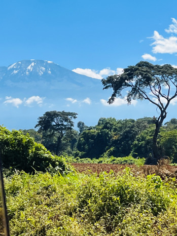
When we drove to our hotel, I got a good first glimpse of the mountain. The picture does not do it justice how big it really looks.
We arrived at 8pm in Moshi at 888m altitude. Keys hotel very is recommendable. Clean, has air conditioning and they were well organized.
Day 1 – Umbwe Gate (1,800 m/5,905 ft) – Umbwe cave Camp (2,800 m/9,186 ft) Hiking distance: 13.6 km Altitude gain: 1696m.
Difficulty: Medium
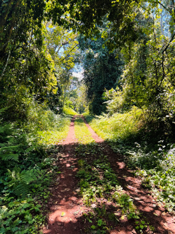
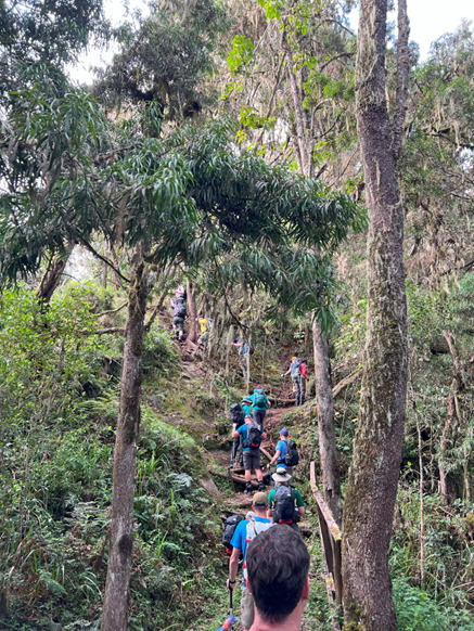
Next morning briefing at 8. We drove 1.5hrs to Umbwe gate at 1800m. After the tourguides organized the porters, loads and paid the national park fees we only started 11:30 on a jeep track through this magical forest.
Quickly in I realised my gaiters were on the wrong feet. Straps should of course be facing out, so they don’t touch each other whilst hiking. Simple mistake due to kit bag stress in the morning which may only weigh 12kg I got it down to 11.99kg!
Climbing higher the forest gets so thick you have no idea how high you are. Passing so called ‘Kili ambulances’ they use to run you down when you have severe altitude sickness makes you hope it won’t be you in the next days. They use 4 porters and in record speed bring you down to a lower and safe altitude to stop the altitude sickness.
The first days are steep climbs on paths naturally formed by the roots of trees.
When you catch a glimpse of some tents knowing you made it to Umbwe cave camp you can only smile. First day done and dusted. That was not so bad…
Arrived at 2850m altitude although everybody’s watch said 2950. It was a quick freshen up, eat and early night. Some had first symptoms of altitude sickness. Vomiting, headaches, and diarrhoea.
Day 2 – Umbwe Camp (2,800 m/9,186 ft) – Baranco Camp (3,950 m/12,960 ft) Hiking distance: 8.8km Altitude gain: 1,150m.
Difficulty: Hard
Next day the forest gets thinner by the kilometre. And the old man’s beard as it is called is more prevailing.

We entered the moorland level of the mountain.
Some pieces were so gorgeous with flowers showing off and giant groundsel called ‘Dendrosenecio kilimanjari’. They are prehistoric roundabout a million years old. They stand about 10 metres tall and can store water in their succulent stems and leaves, which allows them to survive the long dry seasons on the mountain.

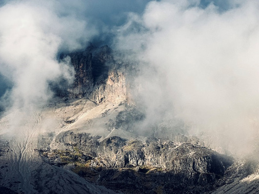
Other areas looked rather grim after the December wildfire. It had a little bit of that eerie sense that you get whilst watching The Lion King. The scene where Simba and Nala explore out of the allowed area and arrive at the elephant head in scar’s territory. The clouds coming in only contributed to this look with a natural fog machine finishing the look off.
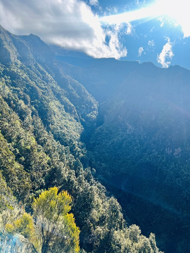
Higher up the spoils of views are just getting better and better. Remember the mountain we flew past? Although still higher in altitude it is as if we finally starting to look down on it.

Day 3 – Climatization Hike from Barranco Camp (3950m / 12,960 ft) – Lava Tower (4630m /15 190 ft) – Barranco Camp (3950 m/12,960 ft) Hiking distance: 5.5 km Altitude gain: 690m Altitude loss: 690m
Difficulty: Medium
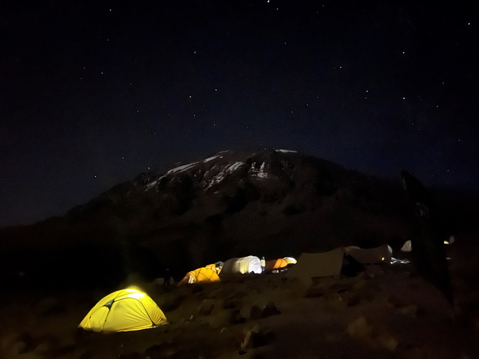
I was so cold that night. I woke up and added layers although the down sleeping bag that was minus 18 rated. Waking up I figured out why at this altitude temperatures started to drop below zero in the night. My tent was covered in frost.
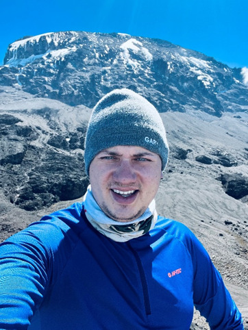
Day 3 was a nice day as we did not have to change camps. Great day to recharge your battery pack. Have a good bird bath after the past days it feels as good as a warm shower. My headaches started to become more severe. A Mybulen did the trick but after every hike from there on it felt like the oxygen shortage gave the headache a reboot. The hike was light. Very scenic with beautiful waterfalls, rock formations, big caves.

Back in the camp it was a show of nature. You could see a curtain of clouds and the next hour it would clear up and you could see down the mountain. Same for the peak. Cover with mist and clouds and after some time the majestic summit would reveal itself.
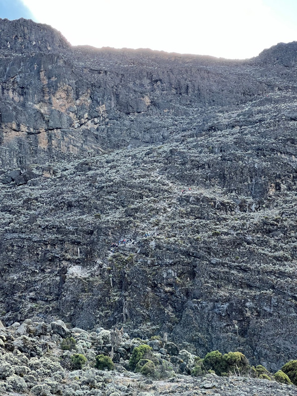
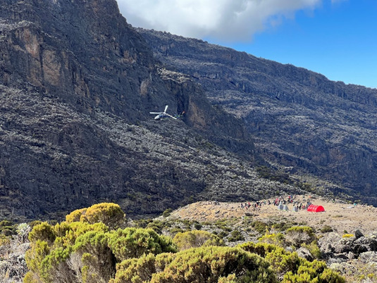
It was at this camp reality kicked in. We could see the choppers flying in and out for medical evacuations. Two team members did not seem to be getting better and did not join on the climatization hike. Nearly 1,000 rescues and ten deaths on the mountain occur each year! We could also see the wall we were going to climb the next day. The infamous Barranco wall a.k.a. breakfast wall / death wall. While climbing the mountain itself is dangerous, the Barranco Wall is a portion of the climb that does not require you to be an expert climber to tackle the wall, but you need to be a smart climber. The Barranco Wall is made up of very steep and narrow paths that require climbers to use all four limbs to traverse the ascent. Why it is called breakfast wall and death wall I would figure out very soon.
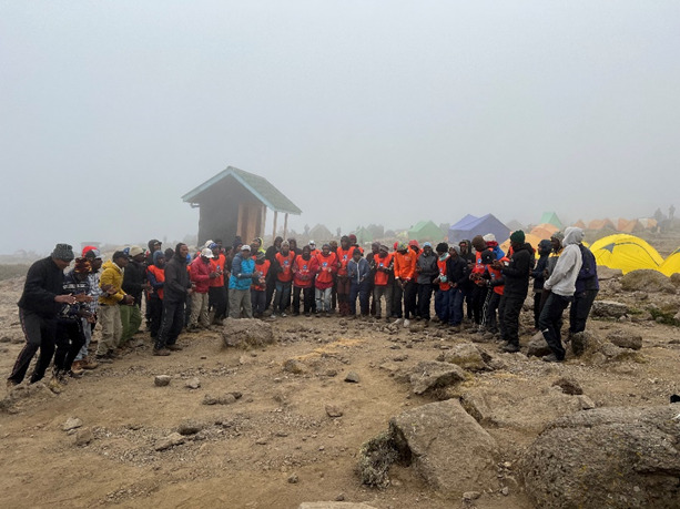
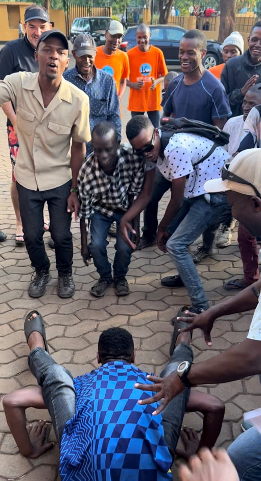
The crew started singing and dancing. I could not understand what they were singing. I believe it was to bless the trip ahead and a safe ascent, especially the tough climb ahead. The team however thought it was a party and we all quickly jumped in with singing and dancing. It was a magical moment. Tanzanians are a beautiful nation. They are so helpful. For if you did not fall in love with their hospitality yet, you probably just did in this moment. For the hard-to-persuade people on the summit, with your lives in their capable hands, you understand how important they are.
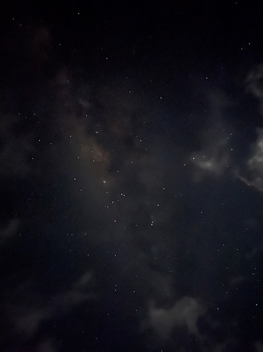
The nights luckily gave some peace of mind as they were gorgeous. I have never seen a milky way that clear. The sheer volume of stars surrounded by stardust was awe-inspiring stunning.
Day 4 – Barranco Camp (3,950m / 12,960 ft) – Karanga Camp (4,040m / 13,255ft) Hiking distance: 8.9 km Altitude gain: 560m.
Difficulty: Hard
We wake up and unluckily one of the kindest guys you will meet could not recover from altitude sickness and decided with the local tour guide leader to take one tour guide and descent down back to the hotel.
Starting the wall, we quickly got the kissing rock section on Barranco wall. There is one section of the trail that is referred to as the kissing wall or hugging wall. This reference is made because of the narrowness of the trail at this point. When climbing this portion, you need to flatten against the wall to avoid falling off a steep drop. While it is not difficult, it can be a bit intimidating. Many climbers will kiss the wall as they pass through. Here I encountered two absolutely opposites climbing the wall. One team member got a freight at this section. I have to say if it wasn’t for the tour guide, she would have probably dropped the mic and shouted, ‘I’m out’. The other person took a sleeping pill as he could not sleep that night but did not check the time so took it at 4am in the morning. We had to wake him up. He was I think still half drowsy and half high just enough to give him the courage as if he was a mountain goat jumping from one rock to another!
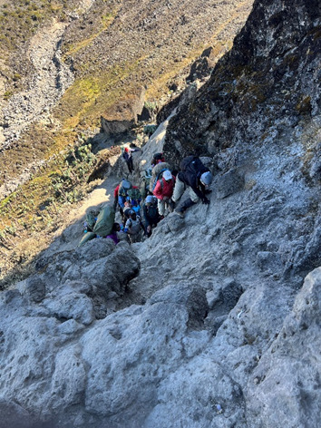
Very quickly the easy climbers all received a rude awakening danger is lurking underneath every rock.
A porter bumped his load at this section and from a serious height and fell all the way down. He was cut open on his arms and legs. Another helicopter was radioed in, and he was taken to hospital. We heard noises he might have broken his back and/or leg. Luckily at the end of the day we got the positive message they were able to stop the bleeding and did not break a single bone! I know understand why it is called the death wall.
After getting to the top Barranco wall I saw a lot of cairns. Often used to mark the summit route. In prehistory they were also raised as memorials. I decided to add a stone for my father. A couple days ago it would have been his birthday. He passed five years ago due to cancer. He was an absolute legend and would have loved for me to embark on this journey. I thought that he might experience it through my eyes with me.

A little bit further up on this beautiful open spot we took some rest, rehydrated, took stunning pictures and everybody dived in his/her backpack for snacks. We were all hungry and now we got the other a.k.a. for Barranco wall. You use your whole breakfast on this wall.
I congratulated a friend of mine that joined the trip. He had been sick since day 2. He was looking horrible. I had seen his face change colour to all the colours of the rainbow (green, yellow, red, pale white). He was so mentally strong. It was not a race and lived by the local motto: pole pole which is Swahili for slowly. At one point you could see Karanga camp. But oh my was it further than your mind maps it out. At one point it reveals a huge valley down and a steep up until you reach camp. As we’ve reached the alpine dessert altitude your trekking poles almost become ski poles. Mind over body one step in front of another he arrived. A bit later but he did arrive.
Karanga luckily was sunny and warm. Because it was not in a valley like Barranca where mist continuously builds up it was a very nice camp. Here we saw another medical evacuation from Stella Point. This must have been hard for that person, 45min away from summit but you get the green not gold certificate for summit.
Day 5 – Karanga Camp (4,040m / 13,255 ft) – High camp: Barafu Camp (4,550m / 14,930ft) Hiking distance: 7.2 km Altitude gain: 729m.
Difficulty: Medium
It was not a harsh hike, not too long to be rested enough for summit night. When we arrived, I saw atent flying down and I could really feel for the porter to walk all the way down the mountain dissemble the tent walk up again and reassemble the tent.

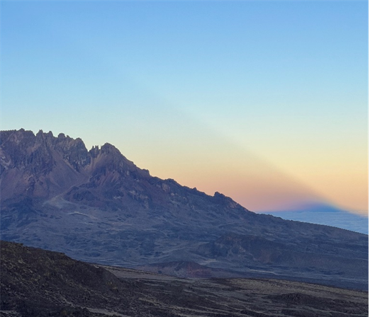
This was by far the least pleasant camp. It was very cold, very windy, and not a lot of shelter. I could not sleep. Partially because of the wind howling and whacking the tent continuously partially because of the excitement now really kicking in. At sunset Mawenzi peak was creating this gorgeous massive shade.
Just after dinner going to bed trying to catch some sleep you take in that last 1000m+ to
Summit with a beautiful sky full of stars backdrop.
Day 6 – Barafu Camp (4,550m / 14,930ft) – Stella Point (5,752m /18,871ft) to Uhuru Peak summit point (5,895m / 19,340ft) and descent to Millennium Camp (3,820m /12,530ft) Hiking distance: 23.5km Altitude gain: 1202m Altitude loss post summit: 2075m
Difficulty: Extreme
We had to ‘wake up’ at 23:00. I believe nobody needed an alarm that night. We filled up our bottles, did a kit check, toilet visit, and we left at 00:00. Whilst walking I heard one of the team members was battling with 60% oxygen levels and mutually agreed with the head tour guide to go down and not continue for summit. The queues were long creating a slow pace. We probably all needed that. With 50% oxygen molecules in the air compared to sea level your heartbeat really goes up fast to distribute the oxygen if you do anything more than one foot in front of another. Slow steep walk up at 120bpm you’re in the sweet spot. Trying to catch up to a teammate it quickly goes over 150. You get fatigued very quickly.
The K2 expert gave us a focus point. Just aim to make it to sunrise. I asked what time roughly and he said I think 4:30. You see people trying to jump the queue and rush later trying to catch their breath and only stopping the train again. My advice just follow the footsteps in front of you. It is not a race; you just want to summit. I saw a lot of people throwing up, some were battling with hypothermia, some were hallucinating. One by one I saw people returning to high camp. One of our team members was walking off the track walking towards a cliff and the tour guide judged for that person to not continue. Most ailments outside of minimum kit requirement and general fitness can happen to anyone. It must have been hard so close but so far away.
The motto on the mountain is to ‘leave no trace’. It was sad to see some spots behind a rock covered with paper and preserved. yeah, I don’t have to delve that deep. Let’s say ziplock bags are essential on a 12 hour hike without toilet facilities. Luckily, I did not have that problem.
Hours go by and you have the feeling they making you walk in loops. Same massive three-story high rock I’m sure I have passed three times already. 4:30 comes no light. At that point I had to dig deep. It really at that point becomes a lonely experience. The chats and banter are all gone. Everybody needs all their oxygen. At this point you really starting to respect the tour guides. Whilst you’re walking tiny steps at a time on a switchback lava gravel path they run up and down vertically cross paths to help the one and run down to help the others. They are super humans and help you at that time to tell yourself come on you got this! Finally, this copper glow starts to the come from the skyline and creates this beautiful earth shaped ring. From that time everything gets better. Temperatures rise quickly and the more light comes through the more energy you get back in your ice cold body.

You hit stella point and you know you are 45 minutes away from summit. At this point it is a sightseeing moment. Glaciers, crater rim, looking into infinity. The struggle was all worth it.

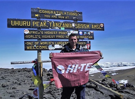
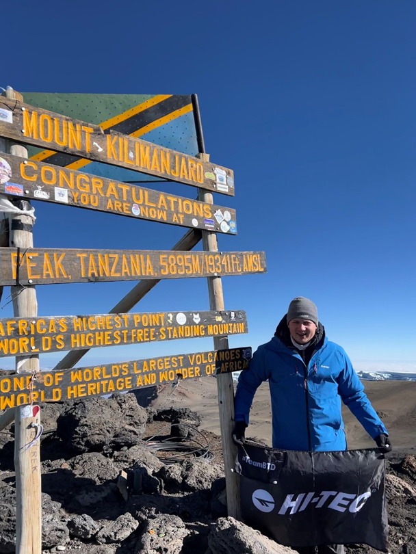
We finally got some banter back. We have been laughing about the word undulating. A person who summited K2’s definition of that word was definitely different to the rookies. Same as the crater rim to the summit. It was supposed to be undulating it was not. But hey, all is forgiven once you have that cool pic on the highest point in Africa, higher than any mountain in Europe and the highest freestanding mountain in the world.
After the celebrations, for some very emotional, reality starts kicking in. You’re only halfway. We all still must go down. You can go down the same path or use your tracking pole to ski over the lava sand where the old glacier used to be. Cutting some time seems like a wise idea. Eventually I ran out of water. UV index was insane high at that altitude. At 12:00 I finally made it to camp. Layered down to an active long tee with a wide brim hat and a buff. At camp I was dehydrated and lightly sunburned through my buff. I was so exhausted I could not even find the energy to go to the toilet and get some water in. I walked straight to my tent and crashed with all my clothes still on. 1.5 hours later I was woken up that we need to go down another camp. I was so disorientated I could not even pack my back. My favourite porter Alfons saw this. He literally gave me water, threw a Mybulen down my throat and just grabbed everything and threw it in my kit bag. Put my shoes back and helped me get my backpack on. Off we went! Altitude is real. Every step down, getting more oxygen in and in combination with the Mybulen kicking in I felt better by the minute. We arrived at camp around 18:30-19:00 and as always tents all set-up and food ready. Everybody had an early night and caught up on some much-needed hours of sleep.
Day 7 (end 12pm) – Millenium Camp (3,820m /12,530ft) descent to Mweka Gate (1,980m / 6,500ft) Hiking distance: 14.3km Altitude loss: 1840m
Difficulty: Medium
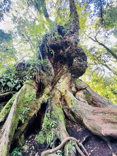
The last day! Spirits are high but the less trained could feel their legs. Scenery was beautiful. They showed the oldest tree in the rainforest.
Muddy and slippery we finally arrived at the gate and the gents started running to the little shebeen. By the time the last person arrived (2hrs later) we finished a fridge. We joined forces with team SA #2. Also, great people! Must be because of the South Africans. We heard one of their team members made it halfway on summit night because of altitude sickness and decided with a tour guide to try again that morning. He made it and arrived the same time as the last of our group. What an achievement! It only shows that will power can be a strong asset to have.

At the hotel was a ceremony where you get awarded your certificate, but the highlight was handing over the tips. We jointly gave USD4900, and they were so happy. They started singing and dancing. We parted ways with a big love and appreciation for the crew. Without them I can tell you we all would not make it or spend double the time on the mountain.
Team SA 1 and 2 had plans to go out that night but the legs were asking us friendly to stay in the hotel. We arranged a Bluetooth speaker and we all played songs, we awarded each other ‘straf doppen’ for what happened on the mountain and the only aching muscle the day of departure back home was the tummy.
Total Hiking distance: 68.2km
Total Altitude change: 7172m / 23530ft
Actual Hiking Days: 5.9
Days to Summit: 4.5